Friday evening update: Few sprinkles today, not bad. Sunday still looking dry. For tomorrow, from our local NWS forecaster:
Saturday and Saturday night…Forecast Confidence is Medium.
Unsettled weather is expected for Saturday. Showers and a few
storms will likely be ongoing to start the day over southwestern
WI. Heating and increase in instability will gradually increase
shower/storm chances through the day. Not looking at an all
day washout, but coverage should increase in the afternoon
through the evening hours. A few strong storms are
plausible, with a risk for localized damaging wind gusts and
small hail. Locally heavy rain is possible, but it looks like a
boom/bust day where some folks get dumped on, and a few miss out.
Showers/storms will persist into the evening before shifting
east/northeast overnight Saturday night.
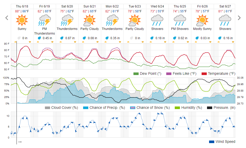
Water levels are back down where we need them to be and sandbars are out! This last stretch of perfect weather was a huge help. The downside to this upcoming weekend is that the mass of high pressure keeping us dry is breaking down and it seems very likely we’ll be hit with a few fronts between Friday and Monday – you’re definitely gonna want to bring the rain gear and some tarps.
Models have been fluctuating all week and there’s still only a medium confidence level in them. Current predictions are up to 50% chance of some isolated rain and maybe thunder Friday afternoon/evening followed up by up to 75% chance of another slow moving front on Saturday that will bring possibly an inch of rain over the course of the day. Luckily there’s not a big risk of storms (<5%). But hey, Sunday is nice!
As for how this might affect water levels – the fronts are pretty widespread across the state so it’s possible we could see sandbars go back under for a couple days. If that happens, it shouldn’t be until maybe Tuesday.