
Update: July 20, 2019 7:04am
Water is beginning its drop and should be reasonable tonight (still fine as is at 12kcfs but will be happier below 10kcfs for extra sandbar availability). Forecast models look to be bringing a single storm through sometime this afternoon with some lingering rain and then clearing out for the evening/Sunday. Main concern is wind and it’s interaction with your tent though given early afternoon timing, the bigger concern is probably not getting stuck on the water in the prestorm wind. If you feel it coming, settle for the nearest sandbar or just be ready to wait it out from shore and then continue on.
Update: July 18, 2019 1:11pm
Sweet baby Rodgers, it just dropped 3.5kcfs at Castle Rock which’ll take ~36 hours to reach us. That translates to ~10-12″ of extra sandbar height. This is great news for those of us camping out Saturday night. Friday night will be tighter but we’ve only got 12-15 different groups then so shouldn’t be an issue.
Side note, if you see a group of 8 adults wrangling 10 tiny children on a sandbar Saturday and Sunday take pity on them. And then wave, that’s us!
Update: July 18, 2019 12:51pm
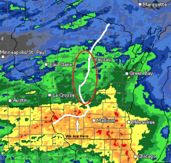
We had quite the train of storms come through early this morning. It tracked more south than initially predicted which is good and bad. Good in the sense that it missed the area outlined in red on this picture. This amount of rain in that area would really shut us down as it would all concentrate just upstream of us. Bad because they were already dumping reservoir water up north in anticipation and now we’ve got that water plus a few inches of local rain all at the same time.
It’s not enough that we’re worried about cancelling trips but it does mean that sandbars will be smaller/fewer than initially expected so don’t be surprised if you end up a little cozier with the group next door. All indications are that this will still drop quickly once they cut back up north so I’ll be sitting here continuing to hammer the F5 key until I see that happen. Ideally it will still be in time for Saturday night but the drop may still be pushed back into very early Sunday morning.
==========================
Things are on track for a solid weekend! It’s a got it’s quirks but a nice change of pace from the crazy we’ve been dealing with all spring.
Some of those quirks – 108 degree heat index for Friday. That’s warm. I did a trip with three straight days of actual temps above 100 and we literally spent more time floating alongside our canoes rather than in them. When the sun came up at 5:30am, you knew. That picture of us sitting around the table in three feet of water? 8am and 95 degrees.
Luckily, the heat starts to give way over the weekend as a ‘cold’ front comes through our area. This may set off some scattered storms and a lot of (probably welcome) cloud cover but overall precipitation currently looks to be under an inch so no concerns about high water (but watch out for accompanying wind and prepare your tent with guylines or temporarily dropping the poles when the wind kicks up). Temperatures will be back into the upper 80s Saturday with reasonable sleeping weather that night and back up to just the low 80s on Sunday and a break from the humidity.
We’re gonna have a quick rise in water levels Thursday and Friday then receding very quickly back down to seasonal levels through Saturday and into Saturday night as the reservoirs and dams in the central part of the state prepare for rainstorms predicted over the next few days up there. If you’ll be out between now and Friday, give yourself an extra 6-12″ of sandbar just in case.