Update: 7/24 12:12pm
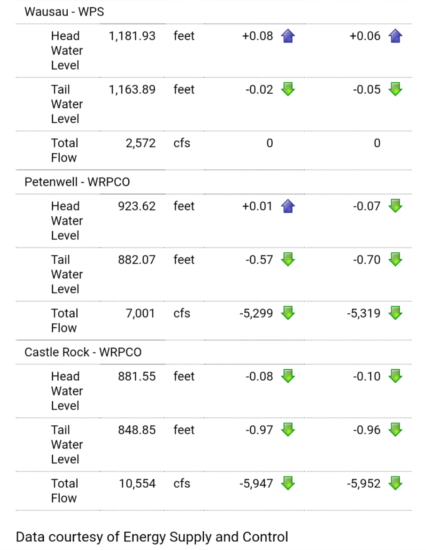
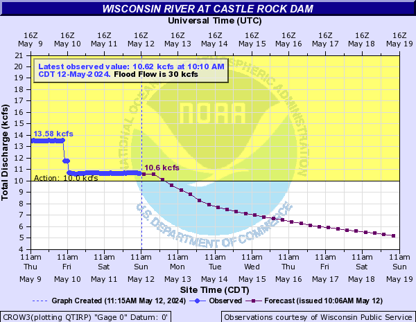
Nailed it. Dam at Castle Rock just dropped to 10.5kcfs (my graph doesn’t reflect this at time of post but my data straight from the source below does) which should get us to ~13kcfs here with room for error under our 15kcfs cap. I’m expecting this flow rate to mostly hold through the weekend or drop marginally given tributary flowrates.
This 12-13kcfs flow rate is close to what I was out in last weekend when we were sold out and didn’t see much crowding on sandbars so while sandbars won’t be the size of football fields, there should be space for everyone. Trips will begin going out as scheduled Friday morning.
Update: 7/24 10:07am
Coming down to the wire for Friday trips. There’s good news 48 hours upstream, now just waiting to see it happen at 36 hours (Castle Rock) before making an official call one way or the other. My only hesitation here is that the Yellow River (the only major tributary between Petenwell, 48 hours upstream, and Castle Rock, 36 hours upstream) is running at 96% of it’s median flow rate, i.e. high. USGS Gauge says it’s adding an additional 4kcfs which, if accurate, is crazy for a river that normally contributes .15kcfs.
As for the rest of the weekend, I’m really starting to think we’ll have sandbars by Saturday (albeit fewer and smaller than normal). As soon as this graph for Castle Rock gets at or below ~10kcfs we’ll be in good shape a day and a half later. For Friday trips to go out, I want to see it happen before 3pm today. 3pm tomorrow for Saturday trips.
Update: 7/23 7:21am
Still feeling pretty positive about this weekend. Real test will be by tomorrow (Wednesday afternoon) when actual water levels that we’ll see start getting released up north. But for now, the numbers coming out of the central part of the state are promising. Everything above 48 hours upstream looks great. There’s currently a 20 kcfs discrepancy at that point (Lake Petenwell/Castle Rock) where 2-3kcfs is normal and the reservoir levels at Petenwell are plunging and nearly back to normal. Combined with the dry forecast, this leads me to believe we’ll see some major cuts in flow rate up there very soon lest they draw down too far. I’m guessing that’ll probably happen later today/overnight. Regardless, if that cut happens before noon on Wednesday we’ll be good to go for Friday and beyond. Any changes will be reflected in the graph below usually twice a day (morning and late evening).
=================================
We squeaked through the weekend with only 30 minutes of rain and decent, if still somewhat elevated, water levels. That’s now over as all of the storms across the state on Thursday, Friday, and Saturday have made their way into the river system. Our stretch will be underwater by this evening and peaking sometime Tuesday or Wednesday in the mid to upper 20kcfs region (we aim to be under 15kcfs, normal is 7kcfs).
The weather forecast for the week ahead couldn’t be more perfect to try and dry out before the July 26-28 weekend. High pressure, low humidity, lots of sun, and minimal chance of rain. From what I can see right now, we’re definitely out of commision through at least Thursday. Friday is my stretch goal but I’m still mostly optimistic about Saturday. It’s very likely the current river predictions will adjust in a favorable direction over the next day or two as tributaries become more stable and we can get a more accurate idea of what’s happening.
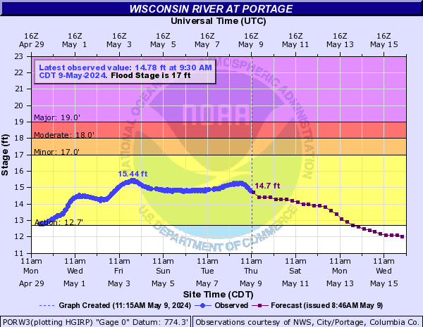
Keep an eye on the graph below for those updates. This particular gauge is about 12-24 river hours upstream of us so what you’re seeing here is like seeing a day or so into the future. We’re looking to see this reading below 13.5′