3rd year in a row where I think maybe we should just stay closed until July…
The storm wasn’t so bad in the lower 2/3rds of the river. Unfortunately, the northern 1/3rd did get 3-4″ of rain. From what’s happening now up in Merrill/Tomahawk area, it’s not a question of ‘if’ we’ll lose sandbars, it’s ‘when’. The timing, once again, puts that water getting to us right in the middle of the weekend. I think Friday night might be fine, but Saturday night would be sketchy and it’s more than enough for us to call off overnight trips for the weekend. Day trips will still be fine – there are places to stop, just not enough to camp on (you could also cancel your day trip as well).
If you’ve got a trip going out this weekend, we’ll be in touch shortly. While the current default is to cancel trips, there’s an outside chance that the rising waters won’t reach us until Sunday so if you’re really itching to go, you can hold out hope for another day or two before we might break your heart again. Our answer came pretty quick – most sandbars will be at or below water level sometime early Friday.
PREVIOUS UPDATES
Quick update for Tuesday night before I can make a more thorough one Wednesday evening:
The most recent forecasts released for river levels seem way too unrealistic. Most of the rain (so far) has fallen to the west of the river valley and the river level forecast is higher with 1/3 (so far) of what we got two weeks ago. I have to believe we’ll see this revised down in tomorrow’s updates.
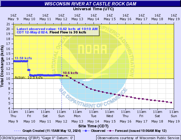
Where will that leave us overall? Still too soon to tell but my feeling is that we’ve got a 50/50 chance of water levels staying below where we need them to be. In addition to the previously posted graph, I’m also keeping an eye on this one below. We’d like to be under 13.5′ More tomorrow evening.
First, special thanks to everyone that went out this past weekend. We were hit with a huge rush of last minute reservations and this brought to light a few flaws in our modified COVID operations. But almost every one of our customers pulled through, followed directions, and were able to enjoy one of the best early season weekends we’ve had in quite a while. Thanks for that!
As for this coming weekend, well, it could be interesting. The weather looks absolutely perfect again. The sticking point will be whatever happens tomorrow night as the remnants of a tropical storm pass over the state. Current predicted rainfall amounts are (and have been) pretty consistent around the 1-1.5″ mark and that’s likely to cause problems this early in the year over such a widespread area.
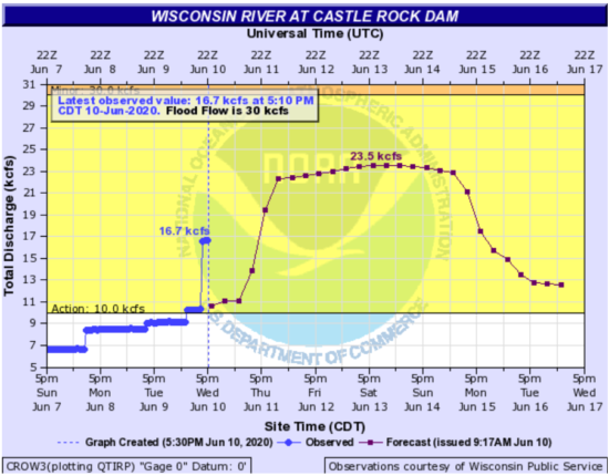
The dam at Castlerock (36 hours upstream, the nearest dam that has control over the amount of water they can hold back or release) has gotten a jump on the forecast and while I’ve posted the NWS hydrologic predictions below, the prediction hasn’t taken the current release into account at the time of this writing. It’s likely we’ll either see sustained high but not ‘no sandbar’ high water through the week, or we get completely washed out and flow rates up north quickly rise Wednesday reaching us in the middle of the weekend. More updates as the data starts coming in Wednesday.
This all assumes we get a lot of rain in the ‘wrong’ places. If you want the finer points, here’s what our local NWS forcaster is pulling from the models: precipitable water values of 2.2-2.4 inches (I believe this is at or above record level), high precipitation efficiency, and strong lift are all very favorable for heavy rain and possible flooding, but the heavy rainfall axis remains over western WI (good for us if it can stay west of the central river valley) along the track of Cristobal. The probabilistic rainfall forecast based on the 25-75th percentiles from the [models] ranges from 1.25-2.5 inches over south central WI with 0.5-1.0 inches over far southeast WI. Probability for 2+ inches is at 60 percent over far western WI to 40 percent in Madison and less than 10 percent for far eastern WI. Fast movement may lower risk of flooding.