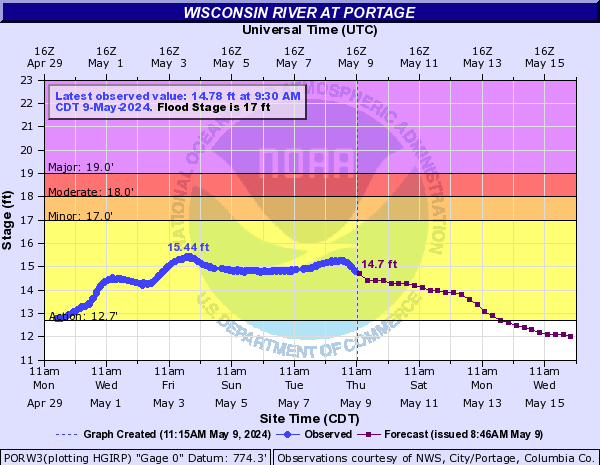
A very narrow storm rolled through last night and while overall rainfall totals weren’t a lot, it sat right on top of the entire river valley. Unfortunately, this has resulted in a pretty large spike in water levels throughout the whole system upstream of us. We’ll see the amount of water more than double between now and Sunday night and while we should still have a few sandbars, it’ll be a far cry from where we are now.
Trips going out midweek should be okay finding places to camp as things currently stand though I’ll be watching closely for updates. For this coming weekend, current river predictions have us coming back down pretty quick, just in time for Friday BUT, there’s also rain in the forecast statewide for Monday so we’ll have to see what happens there before we’ve got a real good idea on timing.
This is a tricky time of year for water level predictions as the agricultural fields start to green up and take in a substantial amount of rainfall. Before that happens, rain mostly runs straight into the water shed i.e. the river which causes the big surges in water levels. The current predictions are still pretty fresh and could be revised downwards as more data comes back on what the rivers are doing and when. Long story short, wait and see. We’d really like the graph below to stay under 13.5 feet.
-Ryan