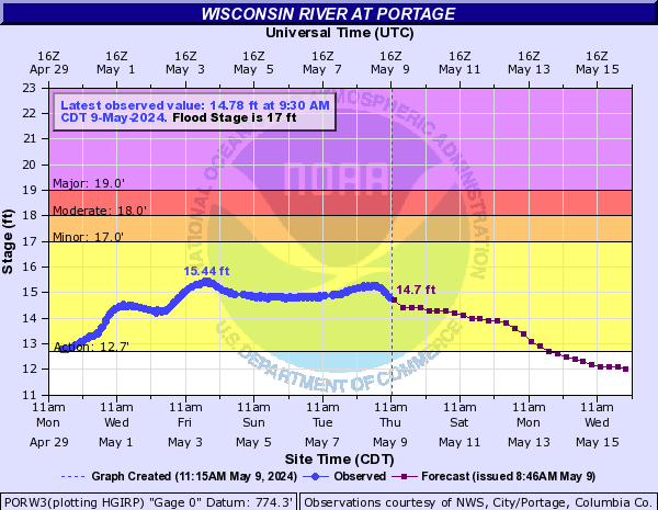
Once again we find ourselves stuck in an unstable weather pattern with water levels predicted to spike next weekend (currently somewhere around 25kcfs, most sandbars go away at 15kcfs). This is a real repercussion of climate change in the Midwest as storm systems have become more erratic and intense.
The rate of warming in the Midwest has markedly accelerated over the past few decades. Between 1900 and 2010, the average Midwest air temperature increased by more than 1.5°F. However, between 1950 and 2010, the average temperature increased twice as quickly, and between 1980 and 2010, it increased three times as quickly as it did from 1900 to 2010. 1.5°F doesn’t sound like much but it is a huge statistical movement. This is an absolutely massive amount of additional energy that needs to go somewhere, and often you’ll find it driving more power into these storm systems.
These are the observed results of thousands of different observations and experiments. Even our own local USGS gauge readings dating back 100+ years has shown a noticeable increase in river variability and increasing periods of high water, particularly over the past 10-15 years. Long story short, expect our questionable spring conditions to continue, both this season, and all seasons thereafter.
Watch the graph below to see what might happen over the next week. Forecasts are updated twice a day during high water conditions. We’re aiming to be at 13.5′ or below.