
Thursday night update: drops in water levels out of Castle Rock earlier so we’ll get a little breathing room here by Saturday night.
Wednesday evening update:
Man, this is so painfully similar to a few weeks ago when we called trips as good to go, but then I undershot the actual water levels. It was a terrifying night watching the hourly dam flow rates come in at the mid 18,000s with 300 of our people camped out on the river. But, in the end, every group was able to find a place to camp, in some cases, just barely.
With that in mind, here’s the final update on this weekend – water levels will be in the 16-18kcfs range until Saturday evening. It’s very likely we’ll start to see a drop overnight Saturday but it’s not a sure thing yet and sandbars will still be small (will try to update as soon as it’s guaranteed, likely Thursday night). That’s not great but the water trend is 100% down so it’s not going to force us to cancel overnight trips, though I wouldn’t recommend going out at these levels (anyone wanting to cancel their trip with us this weekend is more than welcome to do so for a full refund).
To put that 16-18kcfs number into perspective, at 18kcfs we’re at 4’2″ deep. For fun: normal levels at this time of year are 1’6″ at the gauge. Our normal cutoff is 15kcfs (3’7″) which is the most conservative on the river, most other outfitters use 16 or 17kcfs. If it were at 3’7″ I’d happily say ‘go nuts’. Sounds crazy to be splitting inches but it makes a difference.
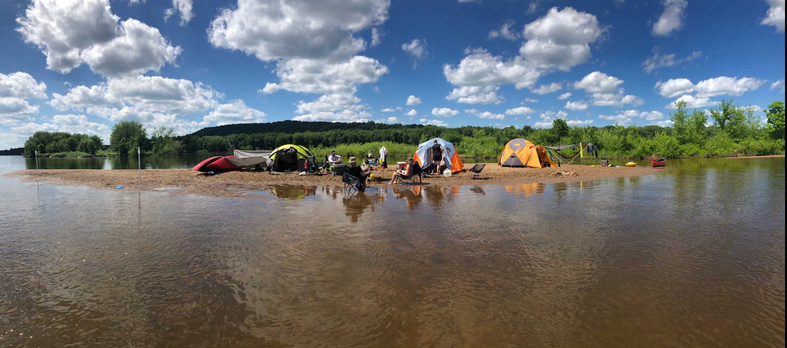
All of that said, current satellite images and personal experience show sandbars are marginally higher this year than in years past – my guess is that it’s a result of the higher and more prolonged flooding we’ve had late last year and early this spring. Don’t get me wrong, most sandbars out there right now are small and infrequent and the larger ones should expect to be shared (though still better spacing than a state park campground), but I think whereas 15kcfs in prior years was a ‘safe’ limit, it could probably be pushed a little bit this year (using the aforementioned experience of a few weeks ago as an example).
Basically, what I’m trying to say in a painfully convoluted way is that no, we aren’t cancelling trips but if I just made you really nervous, you should cancel for a full refund. It’s just such a close call this weekend and I don’t want anyone to feel forced to go out there. And if you do go out, don’t be picky – you find a sandbar that’ll work? Take it.
Tuesday afternoon update:
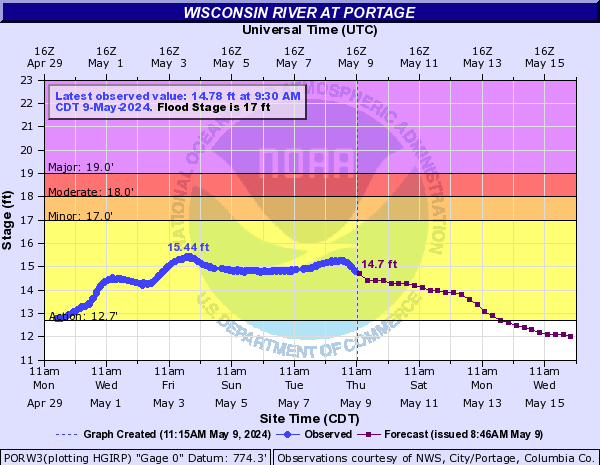
Oh baby. We’re leveling off upstream near Portage much lower than last night’s forecast of 14.9′. Current prediction says 13.9′ and looks like we’re going to undershoot that as well. I’m normally happy at 13.5′ but with how low the Baraboo River is, I think 13.9′ would have still been right there at what I’d like to see by the time it hits us in Prairie Du Sac.
We’ve been rock solid coming out of the regulated reservoir system at Castle Rock so with everything in the lower half of the river system having avoided the rain storms, where we level off is where we’re gonna stay through the weekdays (and then likely falling into the weekend) and right now, we’re coming out as good as could be hoped for. Sandbars will be small, but they’ll be there.
For reference, at anticipated water levels a few weeks ago, we sent out 300 people and every single one was able to find a place to camp). I’ll continue to watch it with another update tomorrow evening for reassurance but it is looking good for getting trips out the rest of this week and through the weekend.
PS: The weather forecast still looks amazing for the next 10 days.
Monday evening update:
Yesterday’s rain up north has made it into the river system and we’ve got a pretty good idea of what to expect now. Good news and bad: by Wednesday water levels will be up to possibly 18kcfs (~4′ deep on our local gauge) which is about 6″ higher than where we’d normally start to think about calling off a big weekend for lack of campsites. That said, water levels in Wausau where most of the ‘damage’ was done have already fallen off their peak pretty quickly and the relatively few people midweek mean there will still be sandbars to be had.
If you’re out Tuesday night, expect to catch a lot of this rise overnight. Levels will go up ~1.5′ over 24 hours (Tuesday evening to Wednesday evening) so make sure your tents and boats are at least a foot above the waterline when you go to bed Tuesday night.
If you’d like to have a good idea of where to aim for a ‘safe’ island in the next few days, these satellite images are from last month at ~21kcfs (6″ higher than where I expect us to peak this week). Keep in mind that islands are the only legal place to camp (no shoreline) and some islands near the former nude beach will also be signed as no camping.
Mazomanie to Arena – https://thebestcanoecompanyeve…
Arena to Spring Green – https://thebestcanoecompanyeve..
I’m still pretty optimistic we’ll be able to run trips as normal this weekend but will need another day or two of data to be sure. In the meantime, you can watch for twice daily updates coming from the River Prediction Center on the graph below. We want to see that number heading towards 13.5′ or less (I wouldn’t be surprised to see the current peak revised down over the next day or two)
Sunday evening update:
There was a lot of rain in the northern third of our watershed over the last 24 hours but most of the remaining two thirds were spared. Water levels are ramping up pretty quick in the Wausau area about 3 to 4 days upstream so we’ll start to see water levels come up probably around Wednesday. The good news is that current predictions wouldn’t shut us down and the weather forecast is 100% amazing statewide with mostly sunny skies and warm temps throughout the next 10 days.
I’m pretty optimistic the rise in water levels will be short lived and start heading down just in time for the weekend; I’ll continue to update here as we get a few more rounds of river forecasts out of the NOAA River Prediction Center.
-Ryan