A Monday evening update for you – southwest WI got socked pretty good, but that’s fairly inconsequential for us. The rest of the state, particularly the watershed, didn’t see a ton of action. And even though there’s a chance of rain pretty much everyday for the next 10 days, the overall rain totals are less than 1/10 of an inch per day which is manageable. If we can get through another two weeks or so until summer really kicks in, water levels will become much less fussy.
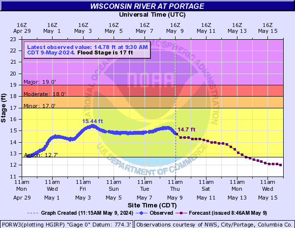
Tonight’s river prediction has us right on the bubble for Friday trips. It’ll take another day or so for the models to gain some accuracy but I wouldn’t be surprised to see water levels come down (marginally) sooner rather than later. In fact, they appear to have peaked a day or so upstream. The graph below is still the one you’ll want to keep an eye on – still aiming to be heading below 13.5′ for a sufficient number of sandbars to return.
-Ryan
Previous update:
This last weekend was a perfect example of why we don’t cancel trips based on weather forecasts. Very little rain, mostly isolated, with great water levels. River forecasts, on the other hand, I pay attention to. And while we didn’t get the rain down here, it did track through our northern watershed again so we’ll see water levels come up for a little while in a few days.
Best guess at the moment: Day trips won’t be impacted. Overnights will be cancelled between this Tuesday until probably Thursday though there will be a small handful of sandbars and next to no one out there so I’d probably send a group out if they knew what they were doing. Tomorrow could change things a fair amount based on how closely rainfall matches the forecast.
Keep an eye on the graph below, we want to see that number heading below 13.5′